West Bank, Gaza and Lebanon Security Barriers:
Background & Overview
by Mitchell Bard
From September 2000 to mid-2005, hundreds of Palestinian suicide bombings and terrorist attacks against Israeli civilians killed more nearly 1,000 innocent people and wounded thousands of others. In response, Israel's government decided to construct a security fence that would run near the “Green Line” between Israel and the West Bank to prevent Palestinian terrorists from easily infiltrating into Israel proper. The project had the overwhelming support of the Israeli public and was deemed legal by Israel's Supreme Court.
Israel's fence garnered international condemnation, but the outrage is a clear double standard - there is nothing new about the construction of a security fence. Many nations have fences to protect their borders - the United States, for example, has one to prevent illegal immigration. In fact, when the West Bank fence was approved, Israel had already built a fence surrounding the Gaza Strip that had worked - not a single suicide bomber has managed to cross Israel's border with Gaza.
Israel is Forced to Act
Making Terrorism More Difficult
Other Benefits
Planning the Fence Route
High Tech Fence
Politics
Precedents
Inconvenience versus Saving Lives
A Barrier For Gaza
The Egyptian Wall
The Lebanon Border Wall
Other Developments
Israel is Forced to Act
The Palestinians committed themselves in the Oslo accords and in the road map to dismantle terrorist networks and confiscate illegal weapons. After more than 10 years of negotiations, and a mounting toll of Israeli civilian casualties, however, it became clear to the Israeli people that the Palestinian Authority (PA) made a strategic choice to use terror to achieve its aims and that something had to be done to protect the civilian population.
“It obliges us to establish a barrier wall which is the only thing that can minimize the infiltration of these male and female suicide bombers,” said Defense Minister Benjamin Ben-Eliezer, who has emphasized that “the fence is not political, [and] is not a border.”
Some Israelis oppose the fence either because they fear it will constitute a recognition of the 1949 armistice line as a final border. Jews living in the West Bank, beyond the planned route of the fence, in particular, argue that they are now being left relatively unprotected and worry that they might be forced to relocate behind the fence if it does become a political border in the future.
Making Terrorism More Difficult
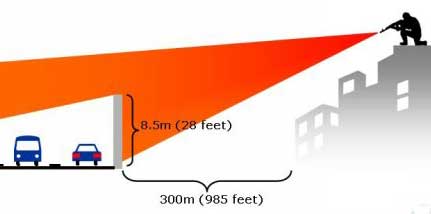
Before the construction of the fence, and in many places where it has not yet been completed, a terrorist need only walk across an invisible line to cross from the West Bank into Israel. No barriers of any kind existed, so it is easy to see how a barrier, no matter how imperfect, won't at least make the terrorists' job more difficult. Approximately 75 percent of the suicide bombers who attacked targets inside Israel came across the border in the area where the first phase of the fence was built.
|
|
During the 34 months from the beginning of the violence in September 2000 until the construction of the first continuous segment of the security fence at the end of July 2003, Samaria-based terrorists carried out 73 attacks in which 293 Israelis were killed and 1,950 wounded. In the 11 months between the erection of the first segment at the beginning of August 2003 and the end of June 2004, only three attacks were successful, and all three occurred in the first half of 2003.
Since construction of the fence began, the number of attacks has declined by more than 90%. The number of Israelis murdered and wounded decreased by more than 70% and 85%, respectively, following the erection of the fence.
Even the Palestinian terrorists have addmitted the fence is a deterrent. On November 11, 2006, Islamic Jihad leader Abdallah Ramadan Shalah said on Al-Manar TV the terrorist organizations had every intention of continuing suicide bombing attacks, but that their timing and the possibility of implementing them from the West Bank depended on other factors. “For example,” he said, “there is the separation fence, which is an obstacle to the resistance, and if it were not there the situation would be entirely different.”
|
|

The value of the fence in saving lives is evident from the data: In 2002, the year before construction started, 457 Israelis were murdered; in 2009, 8 Israelis were killed.
In order to thwart possible Hezbollah infiltrations through the border with Lebanon, in April 2015 it was announced that the IDF had begun construction of a 7-mile long land berm (earth barrier) on the Northern border. The IDF is “executing a significant engineering endeavor, creating obstacles in the terrain so as to use if for our defense” by constructing the border, according to IDF Colonel Alon Mendes. The barrier is expected to be expanded in the future.
Other Benefits
The Green Line is crossed by numerous dirt roads and it is impossible to patrol it. Many Palestinians take advantage of these roads to come to work illegally in Israel or to get between parts of the Palestinian administered territories to avoid checkpoints. Some also cross to carry out terror operations and theft. Since 1994, Palestinians, sometimes in cooperation with Israeli middlemen, have stolen thousands of automobiles as well as farm machinery and animals.1
Israelis living along the Green Line, both Jews and Arabs, favor the fence to prevent infiltration by suicide bombers and by thieves and vandals. In fact, the fence has caused a revolution in the daily life of some Israeli Arab towns because it has brought quiet, which has allowed a significant upsurge in economic activity.
The Palestinians in the territories will also benefit from the fence because it will reduce the need for Israeli military operations in the territories, and the deployment of troops in Palestinian towns. Onerous security measures, such as curfews and checkpoints, will either be unnecessary or dramatically scaled back.
The route of the fence must take into account topography, population density, and threat assessment of each area. The fence is scheduled to be built in stages. Phase A of construction, approximately 85 miles from Salem to Elkana was completed at the end of July 2003. Phase B, which is about 50 miles, runs from Salem toward Bet- Shean, through the Jezreel Valley and the Gilboa mountains. It was completed in 2004.
| The Complete Route |

Phase C of construction incorporates Jerusalem. During the “al-Aqsa intifada,” more than 30 suicide bombings have targeted Jerusalem. A total of 90 terrorist attacks have killed 170 people and injured 1,500 in the capital. The original “Jerusalem Defense Plan” approved in March 2003 called for the fence to be constructed around three parts of the capital, which has been the most frequent target of suicide bombers. This section of the fence was expected to run about 40 miles around the municipal boundaries of the city. Israeli and Palestinian residents in areas along the fence route filed legal challenges that required changes in the construction plan. In March 2005, Israel announced it would build a temporary fence separating Jerusalem from the West Bank by July, leaving the structure in place while legal challenges to the permanent barrier are decided by the courts.
The updated route is to run about 32 miles around Jerusalem, but was only 25 percent complete in July 2005. The fence along the southern rim, encircling neighborhoods such as Har Homa and Gilo is mostly complete. The northern section that will incorporate Pisgat Zeev and Neveh Ya'acov began more recently. The government originally set September 1, 2005, as the deadline for completing the Jerusalem barrier, but shortly after this decision, the Interior Minister said it could not be finished before December or January. As of August 2008, nearly one-third of the fence — about 30 miles of the approximately 100 mile fence — remained unfinished. The principal impediment to finishing the job has been a shortage of funds, however, about 2 miles of the fence has also been held up by ongoing legal appeals.
Phase D will span approximately 93 miles from Elkana to Ofer. In addition, several special sections of the fence will protect specific areas and populations. An inside fence of 15 miles will protect the road from the airport to Jerusalem. A fence around the town of Ariel will stretch about 35 miles and a 31 mile section will traverse the road between Ariel and Kedumim. A 32-mile span will go from Jerusalem to Gush Etzion, another 19 miles will surround Gush Etzion (incorporating 10 settlements and approximately 50,000 Israelis), and the fence will continue an additional 58 miles to Carmel.
The planned route was approximately 458 miles; however, the plan has been repeatedly modified and, in February 2004, the government announced its intention to shorten the route and move the barrier closer to the 1949 armistice line to make it less burdensome to the Palestinians and address U.S. concerns. The announced changes included the dismantling of a small stretch of fence east of Kalkilya to make movement easier for residents going into the West Bank. The government cancelled plans to build deep trenches to protect Ben-Gurion Airport and Route 443 from Modi'in to Jerusalem because of concern about the impact on the Palestinians in the area.
In February 2005, the route was again modified to take into account the decision by the Israeli Supreme Court to take greater account of the impact of the fence on the Palestinians. The proposed route runs closer to the Green Line than the original plan approved in October 2003. For the first time, however, the fence will include Ma'aleh Adumim and the surrounding settlements. To the east of the town, a “ring road” will connect the northern and southern parts of the West Bank, allowing Palestinians to travel between Jenin and Hebron. The route of the fence in the Gush Etzion region was altered to exclude four Palestinian villages whose residents will have free access to Bethlehem. A special protective wall will be built along Route 60 that links Gush Etzion with Jerusalem. The route of the fence in the Hebron Hills, which originally included several settlements and a large expanse of land beyond the Green Line, has been brought close to the Green Line. This new route will include 7 percent of the West Bank on its “Israeli” side — as opposed to 16 percent in the original plan — and approximately 10,000 Palestinian residents.
One of the most controversial questions has been whether to build the fence around Ariel, a town of approximately 20,000 people, the second largest Jewish settlement in the territories. To incorporate Ariel, the fence would have to extend approximately 12 miles into the West Bank. The United States has opposed the inclusion of Ariel inside the fence. In the short-run, Israel decided to build a fence around Ariel, but said in February 2005 it would be incoporated within the main fence at a later stage.
Following months of daily lone-wolf terror attacks dubbed by the “Days of rage” by the Palestinian leadership, Israeli officials announced that Israel would fill in gaps in the separation barrier in Jerusalem, and complete the barrier in Tarkumiya. Some Palestinians who participated in the late-2015, early-2016 wave of violence used gaps in the security fences to enter Israel illegally without proper permits. Lawmakers decided to accelerate the completion of the section of the fence south of Hebron. The route starts at the Tarqumiya checkpoint in western Hebron and extends southward to the Meitar checkpoint, a total of 42 kilometers (26 miles) along bypass Road 35 in the West Bank. The Defense Ministry has finished construction of a 10-kilometer (6.2 miles) section and the remainder is expected to be completed within six months.
As a result of the modifications, the length of the barrier is expected to be approximately 500 miles. As of July 2010, only about 320 miles (64%) of the barrier was completed and much of the rest was tied up by petitions to the Israeli Supreme Court and Justice Ministry deliberations. Work is now being done on mostly constructed sections of the fence and areas that have to be rerouted in response to court rulings. The Defense Ministry previously projected the fence would be completed by 2010, but now it does not give an end date.
The secruity fence is the largest infrastructure project in Israel's history. The cost of the project has ballooned from an expected $1 billion to more than $2.1 billion. Each kilometer of fence costs approximately $2 million.
Israeli Prime Minister Ariel Sharon has said that the “fence is not a political border, it is not a security border, but rather another means to assist in the war on terror.” As such, Israel has repeatedly stated its willingness to move or remove the fence as part of a Palestinian-Israeli peace agreement.
In the past, Israel has been willing to move fences, even elaborate and expensive ones such as this security barrier. Along the border with Lebanon, where a high-tech fence equipped with surveillance cameras and sensors closely monitors the situation, Israel has moved sections of fence more than a dozen times in order to implement its U.N.-certified withdrawal from Lebanon.
Israel has maintained that the security fence will be an obstacle to terrorism, but not to an agreement with the Palestinians. “I do not believe that the routing of the fence can prevent a real accord,” said Finance Minister Benjamin Netanyahu. “A fence can always be moved.”
A High-Tech Fence
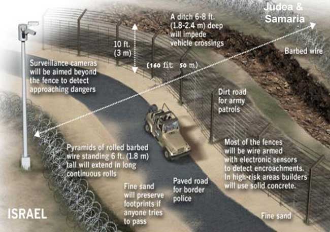
Although critics have sought to portray the security fence as a kind of "Berlin Wall," it is nothing of the sort. First, unlike the Berlin Wall, the fence does not separate one people, Germans from Germans, and deny freedom to those on one side. Israel's security fence separates two peoples, Israelis and Palestinians, and offers freedom and security for both. Second, while Israelis are fully prepared to live with Palestinians, and 20 percent of the Israeli population is already Arab, it is the Palestinians who say they do not want to live with any Jews and call for the West Bank to be judenrein. Third, the fence is not being constructed to prevent the citizens of one state from escaping; it is designed solely to keep terrorists out of Israel. Finally, only a tiny fraction of the total length of the barrier (less than 3% or about 10 miles) is actually a 30 foot high concrete wall, and that is being built in three areas where it will prevent Palestinian snipers from around the terrorist hotbeds of Kalkilya and Tul Karm from shooting at cars as they have done for the last three years along the Trans-Israel Highway, one of the country's main roads. The wall also takes up less space than the other barriers, only about seven feet, so it did not have a great impact on the area where it was built.
Most of the barrier will be a chain-link type fence similar to those used all over the United States combined with underground and long-range sensors, unmanned aerial vehicles, trenches, landmines and guard paths. Manned checkpoints will constitute the only way to travel back and forth through the fence. The barrier is altogether about 160 feet wide in most places.
The land used in building the security fence is seized for military purposes, not confiscated, and it remains the property of the owner. Legal procedures are already in place to allow every owner to file an objection to the seizure of their land. Moreover, property owners are offered compensation for the use of their land and for any damage to their trees.
The construction of the fence has been slowed by political divisions over the precise route. The most controversial aspects of the project are decisions regarding the inclusion of Jewish settlements. Israel wants to include as many Jews within the fence, and as few Palestinians as possible. To incorporate some of the larger settlements, however, it would be necessary to build the fence with bulges inside the West Bank. The Bush Administration understands Israel's security arguments regarding the need for the fence, but does not want it to prejudge negotiations or to threaten the possibility of creating a contiguous Palestinian state and therefore has pressured Israel to restrict construction to the area along the pre-1967 border, or as close as possible to it. The so-called “Green Line,” however, was not an internationally recognized border, it ws an armistice line between Israel and Jordan pending the negotiation of a final border. Building the fence along that line would have been a political statement and would not accomplish the principal goal of the barrier, namely, the prevention of terror.
 |
Most of the fence runs roughly along the Green Line. The fence is about a mile to the east in three places that allows the incorporation of the settlements of Henanit, Shaked, Rehan, Salit, and Zofim. The most significant deviation from the 1967 line is a bulge of less than four miles around the towns of Alfei Menashe and Elkanah where about 8,000 Jews live. In some places, the fence is actually inside the “Green Line.”
The fence especially complicates potential negotiations related to Jerusalem as it will make it more difficult to devise a compromise that would lead to a division of the city, an idea that is unpopular with Israelis. Since the fence is not permanent, it is possible that it could be relocated, or become unnecessary if a peace agreement were reached, in which case a political settlement could be reached.
In the meantime, an estimated 55,000 Jerusalem Arabs from four neighborhoods are expected to be on the Palestinian side of the fence while 180,000 Arab residents of the city remain on the Israeli side of the barrier. Over the past year, thousands of Arab have moved to more central East Jerusalem neighborhoods to stay on the Israeli side of the fence. Representatives of some Arab neighborhoods have gone so far as to petition the Israeli Supreme Court to order the Defense Ministry to reroute the fence so it runs to the east of the neighborhoods of Anata, Ras Hamis and Shuafat and allows them to be on the Israeli side. To alleviate the inconvenience caused by the fence, the Cabinet approved a plan to construct 11 passages through the barrier to facilitate movement in and out of the city. In addition, the government is allocating NIS 8 million for the municipality to provide special services to Arab residents of Jerusalem who will be adversely affected by the fence.
Palestinians complain that the fence creates “facts on the ground,” but most of the area incorporated within the fence is expected to be part of Israel in any peace agreement with the Palestinians. Israeli negotiators have always envisioned the future border to be the 1967 frontier with modifications to minimize the security risk to Israel and maximize the number of Jews living within the State. When the Palestinians stop the violence and negotiate in good faith, it may be possible to remove the fence, move it, or open it in a way that offers freedom of movement. Israel, for example, moved a similar fence when it withdrew from southern Lebanon. The fence may stimulate the Palestinians to take action against the terrorists because the barrier has shown them there is a price to pay for sponsoring terrorism.
Precedents
It is not unreasonable or unusual to build a fence for security purposes. Israel already has fences along the frontiers with Lebanon, Syria, and Jordan, so building a barrier to separate Israel from the Palestinian Authority is not revolutionary. Most nations have fences to protect their borders and several use barriers in political disputes:
- The United States is building a fence to keep out illegal Mexican immigrants.
- Spain built a fence, with European Union funding, to separate its enclaves of Ceuta and Melilla from Morocco to prevent poor people from sub-Saharan Africa from entering Europe.
- India constructed a 460-mile barrier in Kashmir to halt infiltrations supported by Pakistan.
- Saudi Arabia built a 60-mile barrier along an undefined border zone with Yemen to halt arms smuggling of weaponry and announced plans in 2006 to build a 500-mile fence along its border with Iraq.
- Turkey built a barrier in the southern province of Alexandretta, which was formerly in Syria and is an area that Syria claims as its own.
- In Cyprus, the UN sponsored a security fence reinforcing the island’s de facto partition.
- British-built barriers separate Catholic and Protestant neighborhoods in Belfast
Ironically, after condemning Israel’s barrier, the UN announced plans to build its own fence to improve security around its New York headquarters.
Inconvenience Versus Saving Lives
Every effort is being made to exclude Palestinian villages from the area within the fence and no territories are being annexed. The land used in building the security fence is seized for military purposes, not confiscated, and it remains the property of the owner. Legal procedures are already in place to allow every owner to file an objection to the seizure of their land. In addition, Israel has budgeted $540 million to ease the lives of Palestinians affected by the fence by building extra roads, passageways, and tunnels.
Israel is doing its best to minimize the negative impact on Palestinians in the area of construction and has created 70 agricultural passageways to allow farmers to continue to cultivate their lands, and crossing points to allow the movement of people and the transfer of goods. Moreover, property owners are offered compensation for the use of their land and for any damage to their trees. Contractors are responsible for carefully uprooting and replanting the trees. So far, more than 60,000 olive trees have been relocated in accordance with this procedure. In addition, the government has spent NIS 2 billion to construct an alternative system of roads, underpasses and tunnels to facilitate Palestinian travel around the barrier.
Additionally, the Civil Administration in Judea and Samaria opened a District Coordinating Office (DCO) in December 2004, to assist Palestinians living in the Jerusalem area affected by the construction of the fence.
Operations of this office will focus on assisting the 110,000 Palestinians living in Abu Dis and Eizariya, in the areas east of Jerusalem and Kalandiya, A Ram and Bir Naballah to the north. The office will deal with issues concerning education, religion, employment, humanitarian assistance and will coordinate entry of Palestinians into Jerusalem.
Despite Israel's best efforts, the fence has caused some injury to residents near the fence. Israel’s Supreme Court took up the grievances of Palestinians and ruled that the construction of the security fence is consistent with international law and was based on Israel’s security requirements rather than political considerations. It also required the government to move the fence in the area near Jerusalem to make things easier for the Palestinians.
Though the Court’s decision made the government’s job of securing the population from terrorist threats more difficult, costly, and time-consuming, the Prime Minister immediately accepted the decision and began to reroute the fence and to factor the Court’s ruling into the planning of the rest of the barrier.
Palestinians continue to challenge the route of the fence and the Court has issued a number of decisions, some favoring the existing route and others, the petitioners. For example, in June 2006, the Court ordered Israel to tear down a two-mile stretch of fence around Zufin, a settlement near the West Bank town of Kalkilya and reroute it to accommodate Palestinians in the area. In July 2008, the government responded to another court decision and agreed to move part of the barrier that was on the land of the residents of the village of Bil’in.
The security fence does create some inconvenience to Palestinians, but it also saves lives. The deaths of Israelis caused by terror are permanent and irreversible whereas the hardships faced by the Palestinians are temporary and reversible.
A Barrier For Gaza
After Israel discovered that Hamas built a series of tunnels to go under the border fence with Gaza so terrorists could infiltrate with the intention of kidnapping soldiers and attacking nearby Jewish communities, the IDF began taking a number of measures to destroy the tunnels. In addition, an underground barrier designed to prevent tunnels from crossing into Israeli territory was planned to span across approximately 40 miles of Gaza. As of July 2019, about 25 miles had been completed. During construction, the IDF discovered and destroyed 18 tunnels.
A 650-foot sea barrier along the Gaza Strip has been constructed in response to the threat of terrorist incursions by sea. The decision to build it followed the killing of five Hamas naval commandos who tried to infiltrate Kibbutz Zikim during Operation Protective Edge. Construction of the barrier began in 2017 at a cost of approximately 3 billion shekels.
The threat from the sea was highlighted in early 2018 by a senior naval officer who warned, “Hamas sees potential in the sea like they saw potential in their tunnels.” The caution proved prescient when the IDF destroyed a naval terror tunnel in August 2018 which would have enabled terrorists entering from a Hamas military post in the northern Gaza Strip to exit into the sea unnoticed.
The barrier has heavy concrete slabs reinforced with metal rods that extend deep underwater and are equipped with sensors to monitor seismic changes. It also consists of a second layer of armored stone and a third layer in the form of a mound. A 20-foot wire fence above ground with additional sensors and cameras surrounds the breakwater. Observation, control and command centers built along the length of the fence forward information to a command center on a nearby military base.
In December 2021, Israel announced the completion of the Gaza barrier. It is 40 miles long, and cost an estimated $1.11 billion to build. The barrier features a sensor-equipped underground wall to prevent terrorists from digging tunnels into Israel. It also has a nearly 20-foot high above-ground fence with remotely controlled weapons systems and an array of radar systems with cameras that cover the entire territory of the Gaza Strip. In addition, a barrier at sea has sensors to detect incursions from the water.
“This barrier is part of the iron wall of our policy on defense, on the ground, in the air, at sea and in general,” said Israeli army chief Lt. Gen. Aviv Kochavi.
The Egyptian Wall
It is often neglected that the blockade of Gaza would not be possible without Egypt, which also shares a border with the Hamas-controlled territory. Egypt has been working since October 2014 to establish a buffer zone along the border to prevent the infiltration of terrorists and smuggling. In October 2017, Egypt announced plans to extend the buffer zone from about 3,000 feet to nearly 5,000. Hundreds of homes were demolished to clear the area with no outcry from Palestinians or the international community.
On January 27, 2020, Egyptian security and military forces began building a new concrete wall on the Egyptian side of the border with Gaza extending nearly 9 miles from the Karm Abu Salem commercial crossing to the Rafah crossing. The wall, due to be completed by mid-2020, will be nearly 20 feet high and 16 feet beneath the ground. It is in addition to a wall built by the Egyptian army after Palestinians stormed the border in early 2008.
Reportedly, Egypt has coordinated the project with Hamas within the framework of security arrangements aimed at preventing the infiltration of terrorists into the Sinai Peninsula where ISIL and other Islamists have attacked Egyptian soldiers and oil pipelines. The underground portion of the wall is designed to prevent tunnels from being built from inside Gaza, which terrorists have used to infiltrate the Sinai, plant improvised explosive devices, and transport weapons and explosives.
Previously, the Egyptian army destroyed hundreds of tunnels into Egypt dug by Palestinians, which were used for smuggling, drug trafficking and moving people in and out of Gaza. Egypt also created a nearly mile-long buffer zone along the border.
The Lebanon Border Wall
As fears of a future conflict have grown, Israel decided to build an 80-mile security barrier along the border with Lebanon. Lebanese officials have called the plan an “aggression,” however, the entire project was planned, and is being implemented, in close consultation between Israel and UNIFIL, which, in turn, informs the Lebanese army.
The barrier is needed to protect civilians from Hezbollah attacks, but the project has raised tensions with Lebanon, which fears the fence will encroach on its territory. Israel says the entire barrier is being constructed in Israeli territory, and UNIFIL agrees. Spokesman Andrea Tenenti said everything has been built south of the Blue Line (the border recognized by the UN) and away from sensitive areas.
As of September 2018, seven miles of the barrier has been built. Most of the barrier is a concrete wall topped by steel mesh, sensors and surveillance cameras. Steel fencing is used in areas where the wall cannot be constructed. The project is expected to cost $450 million and take two years to complete.
Maj. Tomer Gilad, Israel’s liaison officer with UNIFIL, said there are monthly meetings with the Lebanese military and UN officials. Construction has proceeded “very calmly with the participation on all sides to maintain the stability,” Gilad said. “We expect UNIFIL and the Lebanese Armed Force to maintain stability over here throughout this construction, because this construction is a stabilizing measure.”
Other Developments
In February 2016, Israeli Prime Minister Netanyahu unveiled a multi-year plan to surround Israel with a security fence, stating that Israel needed to protect itself from Palestinian and terrorist infiltration. The Prime Minister made the announcement while visiting a newly constructed fence between Israel and Jordan. He also said that the Israeli government would be looking to permanently fix gaps in the current seperation barrier.
The Israeli Defense Ministry announced the completion of a new 26-mile stretch of it's West Bank border wall on August 3, 2017, running between the Palestinian village of Tarkumia, Northwest of Hebron, and an Israeli crossing near the Meitar settlement further South.
Sources:Near East Report, (July 15, 2002; July 28, 2003);
Jerusalem Report, (September 8, 2003, December 7, 2005, July 10, 2007; July 28, 2008);
Ha'aretz, (February 25, 2004);
Israeli Foreign Ministry;
Ministry of Defense;
B'tselem, (January 15, 2006);
Elhanan Miller, “Land berm going up on Lebanon border to thwart Hezbollah,” Times of Israel(April 15, 2015);
Peter Beaumont, “Netanyahu plans fence around Israel to protect it from 'wild beasts',” The Gaurdian (February 10, 2016);
Barak Ravid, “After Terror Attacks, Israel to Complete Separation Barrier Construction Around Jerusalem, Southern West Bank,” Haaretz, (March 9, 2016);
Anna Ahronheim, Israel completes 10km stretch of West Bank security barrier near Hebron,
Jerusalem Post, (February 5, 2017);
Israel builds new stretch of wall sealing southern W.Bank,
Yahoo News, (August 3, 2017);
Yossi Melman, Hamas’s Dilemma,
Jerusalem Report, (May 29, 2017);
Al-Masry Al-Youm, “Egypt to extend buffer zone with Gaza Strip,” Egypt Independent, (October 7, 2017);
Ilan Ben Zion, “Israeli wall rising near border with Lebanon stokes tensions,” AP, (September 7, 2018);
Anna Ahronheim, “Gaza Naval Barrier Nearing Completion,” Jerusalem Post, (January 1, 2019);
Anna Ahronheim, “IDF Probe Of Gaza Riots Reveals Nearly 1,500 Rockets Fired Since March 30,” Jerusalem Post, (February 28, 2019);
Benjamin Kerstein, “Israeli Military Said to Be Making Significant Progress in Shoring Up Gaza Border Defenses,” Algemeiner, (July 10, 2019);
Adam Khalil, “Egypt building new wall along Gaza border,” Middle East Eye, (February 18, 2020).
Yaniv Kubovich, “Israel Completes Vast, Billion-dollar Gaza Barrier,” Haaretz, (December 7, 2021)
Color maps courtesy of MidEast Web
1MidEast Web
2JTA, (June 18, 2003).
Download our mobile app for on-the-go access to the Jewish Virtual Library